

No Huetter Bypass · Communications
Rathdrum Prairie PEL Level 3 Response
by Brian Rogers 18 min read
On this page
ITD District 1
Attn: Carrie Ann Hewitt, P.E.
600 West Prairie Avenue
Coeur d’Alene, ID 83815-8764
Rathdrum Prairie PEL Level 3 Response
Summary of Five Years of Analysis of the Rathdrum Prairie Planning and Environmental Linkages (PEL) Study and Related Idaho Transportation Department Actions
1. Introduction and Scope
This report consolidates findings advanced by the No Huetter Bypass group over approximately five years of review of the Rathdrum Prairie Area Transportation Study (PEL Study), initiated by the Idaho Transportation Department (ITD) and Kootenai Metropolitan Planning Organization (KMPO) in 2022 and scheduled for completion by the end of 2026. The analysis draws upon publicly released ITD documents, Level 1 through Level 3 screening materials, Purpose and Need statements, public meeting summaries, Federal Highway Administration (FHWA) Planning and Environmental Linkages guidance, and contemporaneous group submissions. The central conclusion is that ITD has not demonstrated that selected designs serve the best long-term interests of the Coeur d’Alene, Post Falls, Hayden, and Rathdrum communities. Designs advanced, particularly those centered on the Huetter alignment, are poorly fitted to the prairie’s existing network pattern, growth distribution, and future mobility technologies.
ITD’s own Purpose and Need Memo states: “The purpose of the transportation recommendations is to improve safety, mobility, as well as system reliability and resiliency for the current and future movement of both people and goods as northern Kootenai County and the Rathdrum Prairie continue to see rapid growth and development.” The group’s review finds that the process has systematically under-documented the dismissal of higher-performing or lower-impact concepts, provided insufficient quantitative detail for meaningful public evaluation, and advanced an alignment that effectively constructs a parallel north-south facility of limited independent utility. Critically, the PEL process as executed departed from the original design intent of identifying holistic solutions and instead constrained community input in ways that prevented integrated, multi-element recommendations during the formative screening stages.
2. Departure from the Original Holistic Design of the PEL Process
The original design of the Rathdrum Prairie PEL program contemplated a holistic examination of the regional transportation system. Holistic planning, by definition, requires evaluation of interdependent improvements, north-south capacity, east-west connectivity, access management, multimodal integration, and local-network support, as a unified set rather than as isolated concepts. During Level 1 and Level 2 screening, however, the community was not permitted to submit or have evaluated feedback packages that incorporated more than one suggestion at a time. Participants were repeatedly instructed that the PEL process was required to remain at a “broad brush” level of detail until the subsequent National Environmental Policy Act (NEPA) phase.
This procedural restriction prevented the public from demonstrating how combinations of modest improvements—such as selected east-west arterial upgrades (including original concepts related to a 16th Street connection between Post Falls and Coeur d’Alene), targeted access control on existing corridors, signal timing and intersection geometry changes, and limited new connections—could collectively outperform a single large new alignment. Level 1 began with 54 concepts that were rapidly consolidated or eliminated; Level 2 advanced only 13 discrete alternatives. The community was therefore unable to test or advocate for multi-element packages until Level 3, at which point the set of surviving alternatives had already been narrowed and the opportunity for genuine holistic synthesis had been substantially foreclosed. The restriction also had the practical effect of privileging those concepts that could be described as stand-alone “big lines on a map,” precisely the form of solution that ITD’s later statements about focusing on larger, higher-speed roads tended to favor.
Ironically, the Level 3 proposals themselves exceed the “broad brush” characterization that had been used to limit earlier input. Level 3 materials present specific alignments, interchange locations, cross-section assumptions, combination scenarios (N+D, N+H, N+D+B, N+H+B), and comparative travel-time results. Yet these materials still withhold the quantitative cost ranges, detailed right-of-way parcel data, origin-destination matrices, and engineering assumptions necessary for the public to determine whether the proposals are valid, cost-effective, or superior to alternatives that were never allowed to be evaluated in combination. The process therefore combined the restrictive features of a high-level screening with the definitive features of a preferred-alternative selection, without providing the information required for informed community consent. The result is a study that is simultaneously too constrained for genuine public synthesis and too advanced for continued claims of conceptual flexibility.
A properly executed holistic PEL would have invited and scored multi-element packages from the outset, published the quantitative performance and impact scores of those packages alongside single-concept alternatives, and retained flexibility for refinement into NEPA. Instead, the public was told that such packages were premature, only to discover at Level 3 that the surviving single concepts had already been combined by the study team into preferred scenarios. This sequence inverted the intended relationship between public input and technical synthesis.
3. Traffic Reality: US-95 as the Dominant Constraint
Empirical traffic analysis conducted by the KMPO and repeatedly submitted by the No Huetter Bypass group demonstrates that US-95 (frequently referenced in regional discussion as the functional equivalent of a primary north-south route and occasionally misstated as I-95) constitutes the largest single constraint within the study area. Group origin-destination review of available count and model data indicates that less than approximately 15 percent of US-95 traffic volume continues past Boekel Road. The large majority of movements are local or short-to-medium regional trips that terminate or originate within the Coeur d’Alene, Hayden, Rathdrum, and Post Falls urbanized area. The study distribution undermines the premise that a new continuous north-south controlled-access facility is required to serve through traffic.
ITD’s Purpose and Need Memo itself identifies US-95 as “the primary north-south thoroughfare and singular north-south highway route in north Idaho” and projects severe future degradation. Northbound US-95 travel time from Lancaster Road to Emma Avenue is forecast to increase from 15:37 to 45:53 in the 2045 PM peak under No-Build conditions. Parallel documentation shows SH-41 from I-90 westbound to Boekel Road rising from 11:05 to 39:28 in the same period. These figures confirm that the dominant problem is capacity and access management on existing primary corridors and their east-west feeders, not the absence of a fourth north-south alignment. Any solution that fails to confront the 85 percent local and short-trip component of US-95 demand will leave the core problem unaddressed while imposing large new right-of-way and fiscal costs on the community.
4. ITD’s Stated Preference for Larger, Higher-Speed Facilities and the Case for Alternatives B and N
During multiple Level 2 and Level 3 public meetings, ITD representatives stated that the Department would focus its attention and resources on larger roads with higher design speeds. This policy posture has the practical effect of elevating Alternatives D and H (both centered on the Huetter corridor, whether as a four-lane arterial or as an access-controlled highway with parallel local roads) while de-emphasizing lower-speed or more distributed network solutions. The No Huetter Bypass group concludes that, given the traffic distribution data and the incomplete holistic evaluation described above, ITD should not advance Alternative D or Alternative H at this stage. Attention and detailed engineering effort should instead be concentrated on Alternative B and Alternative N.
Alternative N, which incorporates an access-controlled alignment along the Pleasant View / parallel east-west corridor together with SH-53 widening and a Meyer Road Bypass element, addresses the documented east-west deficiencies that the Purpose and Need materials themselves identify as critical. It offers a means of relieving pressure on I-90 interchanges and on the signalized sections of US-95 by providing a parallel high-capacity route for longer east-west movements. Alternative B, which in Level 2 screening showed zero or near-zero property and acreage impacts and low relative cost, represents the type of operational and capacity improvement on existing facilities that can be implemented with far less disruption and without new Fifth Amendment takings of the scale required by the Huetter options.
However, Alternative B was not presented with comparable quantitative detail during the Level 3 community meetings. Travel-time tables, cost ranges, implementation packaging, and sensitivity testing for Alternative B remained less developed than those for the Huetter-centered options. The public was therefore left unable to evaluate whether a refined Alternative B, alone or in combination with selected elements of Alternative N, could deliver acceptable performance at substantially lower community cost and impact. This asymmetry in presentation reinforces the perception that the process has been oriented toward confirming a preferred high-speed corridor rather than toward an open comparison of all viable packages. Until Alternative B is brought to the same level of analytical and presentational rigor as Alternatives D and H, any claim that the Level 3 results reflect a balanced evaluation remains unsupported.
5. Critique of Alternative H
ITD materials describe Alternative H as follows: “Alternative H would add an access-controlled highway (with parallel local access roads and interchanges at key crossroads) along Huetter Road from I-90 to Lancaster Road, then along a new alignment going northeast south of the UPRR line to connect with US-95 near Boekel Road. The new Huetter access-controlled highway would have two lanes in each direction with a center median, and a speed limit of 55-65 mph. The existing Huetter Road would serve as a local access road.” Level 2 screening assigned it 429 acres of right-of-way impact, 131 properties, medium residential impacts, and a qualitative “Medium Cost” rating.
Although labeled an access-controlled highway, the design retains a parallel local access road system. It therefore does not satisfy the general engineering definition of a fully controlled-access facility in which abutting properties have no right of direct access. All movements occur exclusively via grade-separated interchanges. The practical result is two roadways operating side-by-side across the prairie. Construction of such a facility requires extensive land acquisition under the Takings Clause of the Fifth Amendment. The group maintains that no public necessity has been established that would justify this taking: the alignment terminates near Boekel Road. It provides no continuous long-distance utility even under 60-year growth projections. It is, in functional terms, a highway that goes nowhere, duplicating what is in place and creating more throughput than can be used by the arterials.
Moreover, even if interchanges are spaced at approximately one-mile intervals as suggested in Alternative H materials, the concentration of entering and exiting traffic at each ramp will generate queues and turbulence that propagate onto the mainline for a substantial portion of that mile. Without coordinated improvements to the local street network that feeds those ramps, meaning any improvements that require active, ongoing partnership with city and highway-district road departments, the “access-controlled” facility will itself become congested at the interchanges. The Coeur d’Alene office of ITD has not demonstrated a working process of joint planning with local road agencies sufficient to prevent this outcome. The result is an impractical solution that merely relocates, rather than resolves, congestion.
6. Potential Violation of Federal Standards
Federal highway design standards explicitly warn against placing major system interchanges (freeway-to-freeway) in close proximity to high-volume local service interchanges. The Huetter design violates this principle by dropping a massive commuter funnel directly between SH-41 and US-95. When we apply the established Catastrophe Model, the inclusion of southern freight acts as an extreme multiplier to the friction variable. You have thousands of local commuters entering I-90 from Huetter. This cross-traffic “weave” forces heavy trucks and passenger vehicles to cross paths within a highly constrained physical distance. The resulting turbulence guarantees that the mainline flow will collapse into a shockwave on a daily basis.
Simultaneously, 23 CFR 771.111(f)(2) mandates that a project must possess “independent utility or independent significance, i.e., be usable and be a reasonable expenditure even if no additional transportation improvements in the area are made”. Alternative H’s proposed design relies on an access-controlled mainline with approximately one-mile interchange spacing, yet it explicitly retains a parallel local road system.
7. SH-41 Access-Control History and Failures of State Legislative Oversight
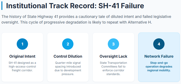
A parallel cautionary example exists in the evolution of State Highway 41. The original design intent for segments of SH-41 contemplated a higher degree of access-control consistent with its function as a principal arterial and freight corridor. Through successive project decisions and legislative and administrative actions, that intent was progressively diluted. The facility was ultimately constructed or reconstructed with signalized intersections first at approximately half-mile spacing and, in critical segments, at quarter-mile spacing. The resulting stop-and-go operation has degraded both mobility and safety and has forced diversion of traffic onto parallel local roads that were never designed for the resulting volumes.
The No Huetter Bypass group attributes a substantial share of this outcome to inadequate oversight by the Idaho Legislature’s House and Senate Transportation Committees. Those committees possess the statutory responsibility to review major highway programming, to question deviations from adopted corridor plans, and to ensure that access-management standards are preserved when projects move from planning into design and construction. Their failure to enforce the original access-controlled vision for SH-41 has produced a corridor that now contributes to the very congestion the Rathdrum Prairie PEL Study is asked to solve. The same institutional weakness increases the risk that Alternative H, even if built with nominal one-mile interchange spacing, will experience progressive degradation through later pressure for additional access points or through uncoordinated local development at the ramps.
Because the Coeur d’Alene-area ITD office has not established durable joint planning protocols with local road departments, there is no institutional mechanism to protect either a future Alternative H or the existing SH-41 from the same incremental erosion of access control. Holistic traffic-pattern management is therefore impossible under current practice. Any claim that Alternative H will remain a free-flow facility for decades must be evaluated against this documented history of institutional failure on a parallel corridor within the same metropolitan area. The same committees that failed to preserve access control on SH-41 continue to exercise oversight authority over the programming decisions that will determine whether the Rathdrum Prairie PEL recommendations advance into NEPA and design. Without a change in that oversight posture, the pattern of progressive degradation is likely to be repeated.
8. Fifth Amendment Considerations and the Absence of Demonstrated Need
The Fifth Amendment permits the taking of private property only for public use and upon payment of just compensation. Where a public agency dismisses demonstrably superior or lower-impact alternatives without documented reasoned explanation, the assertion of “public use” becomes vulnerable to challenge as pretextual. The No Huetter Bypass group has consistently argued that the burden rests upon the State to first convert existing corridors to true access control and to exhaust capacity improvements on US-95 and SH-41 before any claim of necessity can support large-scale eminent domain for a parallel facility. Group submissions state: “It is the burden of the State to make this an access-controlled highway. This must be completed before ‘need’ can be found in taking land for several other projects.”
Federal regulations under 23 CFR § 710.105 and § 710.511 emphasize prudent use of funds and alternatives to minimize takings, such as reusing existing corridors before new construction. The PEL study’s comparative screening notes “Property Impacts: Potential impacts to properties” but does not adequately explore low-acquisition options, violating NEPA’s requirement (23 CFR Part 771) to evaluate alternatives that reduce environmental and community effects, including displacements. However, it is the community’s understanding that even if Alternative D is selected, ITD will request the same amount of land acquisition as in Alternative H. The concept of this is deeply concerning given how liberally the State has pushed for land acquisition when it has not been needed.
Because multiple original concepts, including east-west arterial connections such as an improved 16th Street linkage between Post Falls and Coeur d’Alene, were eliminated in Level 1 or Level 2 screening with no publicly disclosed quantitative comparison of benefits, costs, or property impacts relative to Alternative H, the resulting work products lack the evidentiary foundation required to support taking property. The reports therefore appear disingenuous in their claim that the selected alternatives represent the reasoned outcome of an open, multi-criteria process. The earlier prohibition on multi-suggestion feedback packages further compounds the evidentiary deficit: the public was never allowed to place a holistic lower-impact package into formal competition with the high-impact Huetter options.
9. Insufficiency of Detail Provided for Public Review
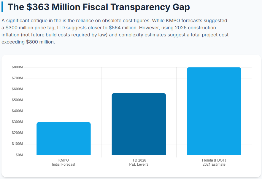
Review of the materials hosted at https://itd.idaho.gov/project/rathdrum-prairie-pel-study/ and associated meeting magazines reveals a persistent pattern: screening matrices employ qualitative labels (“Best,” “Better,” “Medium,” “Negative”) without publishing the underlying numerical thresholds, unit costs, or model parameters. Cost ratings for Alternative H remained “Medium” with no dollar scale attached in Level 2 materials. Independent estimation by the group, using Florida Department of Transportation unit prices adjusted for cross-section complexity, places pavement and basic construction alone near $500 million and total project cost nearer $800 million—far above earlier KMPO figures of approximately $300 million that have not been publicly updated for post-2020 construction inflation.
FHWA PEL guidance requires that planning studies incorporate public involvement of sufficient depth to allow informed comments and to support later NEPA decision-making. The absence of transparent cost models, origin-destination tables supporting the 15 percent through-traffic finding, and side-by-side quantitative comparison of dismissed concepts (including 16th Street east-west options) prevented the general public from conducting an educated review of outcomes. Circular logic is evident: the Purpose and Need is defined by projected congestion; alternatives are then scored against that Purpose and Need; the highest-scoring alternatives are declared to meet the need—without independent empirical testing of whether the underlying growth assumptions or mode-share forecasts remain valid under emerging technologies. The same circularity is compounded by the earlier prohibition on multi-suggestion feedback packages and by the incomplete presentation of Alternative B in Level 3.
10. Level 3 Results, Cost Inflation, and Process Deficiencies
Level 3 advanced combinations centered on Alternatives D (Huetter widened arterial), H (Huetter access-controlled), M, and N (Pleasant View / parallel east-west alignments with SH-53 widening and Meyer Road Bypass). Combinations such as N+H and N+D were presented as offering the greatest travel-time savings relative to the 2045 No-Build. Yet conceptual cost estimates and right-of-way acreage remain incompletely quantified in public-facing materials released through July 2026. Given documented national highway construction cost escalation between 2020 and 2026 driven by materials, labor, and regulatory factors, any earlier $300 million benchmark is obsolete. Continued reliance on qualitative “Medium Cost” descriptors constitutes an inaccurate representation under standard FHWA practice, which expects planning-level cost ranges expressed in constant or year-of-expenditure dollars.
The Level 3 materials further illustrate the tension between the earlier “broad brush” restriction and the current level of geometric specificity. Alignments, interchange locations, and combination logic are now sufficiently defined to constrain future NEPA alternatives. Yet, the supporting cost, impact, and performance data remain too coarse for the public to judge validity. This asymmetry—high definition of preferred concepts, low definition of supporting analysis—undermines the claim that the PEL has prepared an adequate foundation for subsequent environmental review. It also confirms that the process has moved well beyond the conceptual stage that was used to justify the prohibition on holistic community packages during Levels 1 and 2.
11. Prospective Changes in Mass Transit, Trucking, and Vehicle Technology
Over the next twenty years, autonomous driving systems, AI-optimized signal and ramp metering, truck platooning, and expanded shared and on-demand mobility services are projected to increase effective roadway capacity without proportional increases in physical lane-miles. Freight movements are expected to shift toward higher utilization of existing Interstate and principal arterial capacity through coordinated platoons and off-peak scheduling. Mass-transit and micro-transit options, enabled by autonomous shuttles, further reduce the necessity for additional north-south general-purpose capacity. Under these conditions, the marginal value of a fourth north-south facility is low relative to targeted east-west capacity and operational improvements on I-90 and its interchanges—precisely the corridors already identified by ITD as experiencing the most severe existing peak-period congestion. These technological trajectories reinforce the conclusion that resources should be directed toward Alternatives B and N rather than toward the higher-impact Huetter alignments.
12. Conclusion of Principal Findings
The cumulative record of the Rathdrum Prairie PEL Study, when examined against FHWA expectations for transparent planning-level analysis, against the traffic distribution findings, against the procedural restriction on holistic multi-element feedback during Levels 1 and 2, against the documented degradation of SH-41 under inadequate legislative oversight, and against the formal requirements of the Takings Clause, does not support the conclusion that Alternative H or its Level 3 combinations constitute a necessary or proportionate response to the region’s mobility needs. The dominant constraint remains US-95 and the east-west system that feeds it. The progressive conversion of SH-41 from an intended higher-access-control facility into a signalized arterial with intersections as frequent as every quarter-mile illustrates the institutional risks that attend any new high-speed facility in the absence of rigorous legislative oversight and coordinated local road district partnerships.
Future technological trajectories further diminish the marginal utility of a fourth north-south general-purpose facility. ITD should therefore suspend further development of Alternatives D and H, redirect detailed analysis and public presentation resources to Alternatives B and N (with particular attention to supplying the missing quantitative detail for Alternative B), reopen the opportunity for genuine holistic packages that were precluded during the earlier screening stages, and establish formal joint planning protocols with local road departments before any new controlled-access facility is advanced. Until those steps are taken, the work products to date remain disingenuous with respect to the community interest they purport to serve.
In addition, FHWA regulations (23 U.S.C. § 135) require people, not just freight, to be considered without imposing burdens like eminent domain on residents for economic benefits flowing northward. Further, plans should “emphasize the preservation of the existing transportation system” 23 U.S.C. § 135 (d)(1)(H). The Rathdrum Prairie PEL study does not address all of this. In some cases, community members’ land is acquired instead of already owned public land.
Using projected models from KMPO’s current I-90 study, even by 2055, Alternative H will only reduce traffic on I-90 by roughly 16%. However, it will drastically decrease the level of service on I-90, likely to LOS F by 2045.
Respectfully submitted,
The No Huetter Bypass Group