

No Huetter Bypass · Communications
Response to the ITD District 1 Letter of September 4, 2026
Updated by Brian Rogers 21 min read
On this page
No Huetter Bypass Group
Post Falls, ID
October 1, 2026
Idaho Transportation Department, District 1
600 W. Prairie Ave.
Coeur d’Alene, ID 83815-8764
CarrieAnnCarrie AnnCarrieAnn M. Hewitt, P.E.
Technical Engineer Services Leader – Planning
Subject: Response to ITD District 1 Letter of September 4, 2026 — Rathdrum Prairie PEL Study (Key Number 23349)
Dear CarrieAnnCarrie AnnCarrieAnn M. Hewitt:
This letter responds to the Idaho Transportation Department (ITD) District 1 letter dated September 4, 2026, from CarrieAnnCarrie AnnCarrieAnn M. Hewitt, P.E., regarding the Rathdrum Prairie Planning and Environmental Linkages (PEL) Study. The No Huetter Bypass Group reviewed that letter against the Group’s July 2026 Final Report of Findings, the December 8, 2024 Level 2 comment letter, the July 19, 2026 data-access correspondence, ITD’s Level 2 and Level 3 public materials, and the adopted Kootenai Metropolitan Planning Organization (KMPO) 2025–2031 Transportation Improvement Program. This reply identifies gaps remaining after the September 4 letter and requests a bounded, public re-screen that reduces the need to condemn private property. This letter also addresses a pattern in the Department’s responses. Each reply to date has explained the process rather than producing the analysis, and has directed the community to a records counter rather than to a working file. The members of this Group include people who read screening matrices, traffic models, and cost build-ups for a living. They are asking for the underlying numbers because they can use them, and because Idaho Code § 7-705 requires that the least-injury comparison be made before a location is chosen, not afterward. To be precise, the Group has not requested rail service, transit expansion, or any mode shift as a substitute for highway capacity, as ITD incorrectly stated in the past. It has requested that operational and access-management packages on existing corridors be scored against the new-alignment alternatives, at the same level of detail.
Federal aid and Idaho law supply the test that planning must meet before a new alignment can be treated as necessary. The third PEL response contained one typo and an incorrect reference. 23 CFR § 710.101 and Idaho Code Chapter 7 were the intended references. Idaho Code states that, before property can be taken, it must appear that the use is authorized by law and that “the taking is necessary to such use” (Idaho Legislature, n.d.-a). Idaho Code requires that land required for public use “must be located in the manner which will be most compatible with the greatest public good and the least private injury [bold added]” (Idaho Legislature, n.d.-b). Those rules are location and necessity rules. They are not later paperwork for argument after a preferred line is drawn.
The September 4 Letter Does Not Close the Record Gaps
The September 4 letter restates the process as if the process were proof that the public’s analysis was used. It then directs remaining questions to ITD’s public records procedure. That sequence does not answer the Findings Report. It repeats the same three defects: the public was blocked from submitting combined packages while the study team later combined packages itself; Purpose and Need is written so that only large new facilities can pass; and the quantitative files needed to test the Department’s claims remain outside a working-group format. Furthermore, on an initial public records request for PELL meeting minutes, agendas, and attendee lists, the Group has already been asked to pay over $123.74, which ITD is even having a legal team review. A more detailed request could exceed available financial resources, especially since taxpayers already fund ITD. Worse, I was told I had 10 days to respond, but ITD closed the ticket within 48 hours.
Working-Group Statements and Access to the Analysis
Section 1 of the September 4 letter treats meetings and a Community Working Group as evidence of collaboration because those forums “yielded over 50 public-generated corridor concepts” (Hewitt, 2026). The origin of a concept list is not the result of later analysis. The Group’s December 2024 and July 2026 submissions already recorded that multi-suggestion packages were not accepted during Level 1 and Level 2 screening and that consultants described the work as remaining at “big lines” until the National Environmental Policy Act (NEPA) stage (No Huetter Bypass Group, 2024, 2026). Hosting a meeting does not show that SSTI-informed packages, access-management packages, or east-west arterial packages were scored. ITD’s October 10, 2025 letter answered the Group’s request to apply the State Smart Transportation Initiative framework by stating that “participation in that program is not a federal requirement,” and then addressed it as a request for “rail or train-based alternatives” on population-density grounds (Hewitt, 2025, pp. 2-3). The Group’s request concerned the planning method, not rail. That substitution is the pattern the Group has objected to, and it is on the Department’s own letterhead. However, ITD’s interpretation is completely incorrect and contradicts the request, which is growing considerably problematic.
A working group that will not share the analysis behind its claims is not a working group. The July 19, 2026 correspondence documented that information available to consultants and government employees was not available to non-government members on the same terms and that formal channels were required (Rogers, 2026). Section 12 of the September 4 letter confirms that structure. It tells the public to use ITD’s public-records process for “specific records, technical documentation, correspondence, or other information not contained in the publicly available project materials” (Hewitt, 2026). That instruction is a legal path. It is not the collaborative environment claimed in Section 1.
Federal PEL authority makes the distinction material, stating that a planning product is “a decision, analysis, study, or other documented information” produced in metropolitan or statewide planning (Integration of Planning and Environmental Review, 2015/2022, 23 U.S.C. § 168). The planning process must include “public notice that the planning products produced in the planning process may be adopted during a subsequent environmental review process” (Integration of Planning and Environmental Review, 2015/2022, 23 U.S.C. § 168(a)(3)). During environmental review, the relevant agency must have “made the planning documents available for public review and comment” and considered the resulting comments (Integration of Planning and Environmental Review, 2015/2022, 168(d)(5)). FHWA’s PEL questions and answers repeat that the planning process “shall include public notice that the planning products may be adopted” and that the agency “shall make the planning documents available for public review and comment” (Federal Highway Administration [FHWA], 2016). It does not say “abbreviated” or “summarized” documentation, and it does not say ITD “selected” documentation. Sending the public to a records clerk after screening has already narrowed the set is not that review.
It appears like ITD is saying that it has fewer requirements for the Idaho taxpayer than an MPO would when designing a long-range plan. An MPO’s participation plan must describe its procedures for “making public information (technical information [bold added] and meeting notices) available in electronically accessible formats and means, such as the World Wide Web” (23 C.F.R. § 450.316(a)(1)(iv)), and for “providing timely notice and reasonable access to information about transportation issues and processes” (id. § 450.316(a)(1)(ii)) which is debatable that ITD is following this given the comment deadlines from the last public meeting there would not have been enough time to request all the pertinent information due to how long it took ITD to respond to a simple request. Whatever ITD’s obligations are as a State, the federal planning rules do not contemplate that the technical basis of a corridor screen reaches the public only through a fee-bearing records process. When KMPO updates the metropolitan transportation plan, it must “base the update on the latest available estimates and assumptions for population, land use, travel, employment, congestion, and economic activity” (23 C.F.R. § 450.324(e)). A PEL screen whose results are intended to flow into that plan and into NEPA should be able to show the same inputs. Color labels on a face matrix do not meet the standard required for Level 1 and Level 2 screening. Level 3 details will be addressed later.
The Combination-Analysis Loop
Section 2 of the September 4 letter states that analyzing “multiple combined alternatives with 50 concepts could be overwhelming and cost prohibitive” and that “it makes sense to narrow the alternatives down before combining scenarios” (Hewitt, 2026). The public was told that combination was premature. The study team then combined surviving concepts at Level 3 into packages identified as N+D, N+H, N+D+B, and N+H+B and used those packages as the comparison set (Hewitt, 2026; Idaho Transportation Department, 2026b, pp. 28–29). The agency reserved to itself the synthesis it denied to the public.
Cost of analysis is not a statutory exception to least private injury. If the packages most likely to avoid condemnation were never scored as packages, Idaho Code cannot be shown to have been applied to location choice. A later NEPA document cannot cure a screening record that never placed those packages in competition. The September 4 letter treats that omission as administrative convenience. It is an evidentiary gap.
The same section asserts that the July 2026 Level 3 magazine and a screening-matrix handout now supply parcel counts, acreage, displacements, conceptual costs, origin-destination information, and engineering assumptions (Hewitt, 2026). Section 10 of the same letter then states that the figures “represent the Level 3 screening results and are appropriately characterized as conceptual” and that more detailed estimates “would be developed during subsequent project development and environmental review if a particular alternative advances” (Hewitt, 2026). Those two paragraphs cannot both be a complete public record. Conceptual totals that the author later describes as not yet detailed are not a basis on which the public can judge necessity.
Section 9 of the September 4 letter points readers to an Alternatives Evaluation Process Memo for the numerical thresholds behind the qualitative faces, then prints a URL that ends mid-string at “23349-M-20250731-Rathdrum-” (Hewitt, 2026). The Group located that memorandum independently. It is the July 31, 2025 Alternatives Evaluation Process Memo from CarrieAnnCarrie AnnCarrieAnn Hewitt, Jerry Wilson, and Mike Hartz to Sajonara Tipuric, FHWA Idaho Division. Table 3 of that memo does state the 1-to-5 bins used to paint the faces: intersection cross-product and driveway-density cutoffs; percent reduction from No-Build in segments above 0.9 volume-to-capacity; travel-time savings in vehicle-minutes; vehicle-miles and vehicle-hours traveled deltas; parcel and acre bands, including residential and commercial acreage; impervious-surface, floodplain, and wetland acre bands; noise-receptor counts; and construction-cost bands from less than $250 million to $1 billion or more. Those cutoffs were not printed in the Level 1 or Level 2 public magazines, so commenters could not test a face against a number when screening the alternatives.
Even with Table 3 in hand, a reviewable PEL screen is still missing the computed values that placed each alternative in a bin, the travel-model version and calibration year behind the volume-to-capacity and travel-time scores, the unit prices and contingencies behind the cost bands, and any Highway Safety Manual predicted-crash results at Level 2. Level 2 safety is scored on intersection cross-product and driveway density rather than crash frequency or severity. “More local access” is scored as Best, while Need 1 of the Purpose and Need Memo lists driveway and angle crashes (HDR, 2024, pp. 2–3). Transit is scored with the same volume-to-capacity cut used for automobiles. No stand-alone transportation-system-management, access-management, or high-crash-intersection package appears in the Level 2 range. Those omissions matter for condemnation risk: the scoring machine counts acres, but it does not first ask whether access management, signal progression, lighting, and selected grade separations on SH-41 and US-95 would meet purpose and need on existing public right-of-way. FHWA has stated that “the public has valuable insight about the needs of the community and the performance of the transportation system” and that Section 168 “has specific public involvement requirements relating to availability of documents and opportunities for notice and comment” (FHWA, 2016). A truncated citation, followed by bins without the scores that filled those bins, does not satisfy availability or the original requirement that this information be presented at Level 1 and Level 2.
The Existing-Corridor Loop on U.S. 95
Section 3 states that converting U.S. 95 to full access control was considered and rejected because “the right-of-way acquisition and structural modifications required to construct safe interchange spacing present overwhelming implementation and financial barriers” (Hewitt, 2026). The letter cites Level 1 concept identifiers in a 2024 meeting summary. It does not reproduce the parcel, structure, and cost comparison that would make the word “overwhelming” reviewable. Restating a Level 1 conclusion is not the missing comparison.
The loop is the next sentence. Developed frontage on the State’s primary north-south highway is treated as a reason not to take land there. The same letter then defends a new Huetter-corridor facility with a parallel local access road as standard practice (Hewitt, 2026). ITD’s own Level 3 Alternative Impact Summary prints Alternative H at 112 parcels and 256 acres of right-of-way potentially acquired, against 78 parcels and 100 acres for Alternative D, and its combinations table prints Element B at zero parcels, zero acres, and zero displacements (Idaho Transportation Department, 2026b, pp. 16–17, 28–29). Rejecting access control on an existing highway because it would take land, then advancing a dual new roadway that would take more land, inverts Idaho Code.
ITD’s own Purpose and Need discussion, as quoted in the Findings Report, identifies U.S. 95 as the primary north-south thoroughfare and forecasts severe peak-period degradation on that corridor under No-Build conditions (No Huetter Bypass Group, 2026). The Group’s origin-destination review of available counts provided by KMPO’s technical information indicated that only a minority of U.S. 95 volume continues past Boekel Road (No Huetter Bypass Group, 2026). Until ITD publishes the origin-destination files cited in Section 2, the public cannot test whether a new facility to Boekel is necessary or whether it mainly relocates local trips.
Circular Purpose and Need and the Demotion of Lower-Taking Work
Section 4 states that larger, higher-speed roads are “coincidentally” the facilities most likely to need federal aid and NEPA review, and that smaller local projects “do not fully meet Purpose and Need as a stand-alone alternative” (Hewitt, 2026). The letter then says that widening U.S. 95 to six lanes, as portrayed in Element B, “just doesn’t address the purpose and need of our Rathdrum Prairie Area Transportation Study addressing the Rathdrum Prairie area” because improvements to U.S. 95 “tends to impact only the US95 area” (Hewitt, 2026). That is a circular definition. If Purpose and Need is written around a prairie-wide new alignment, only a prairie-wide new alignment will pass. The circle is not evidence that existing corridor operations fail.
The practical effect is to park the measures that reduce conflict points and avoid condemnation. Access management, signal operations, selected grade separations, and surplus driveway removal can often be delivered inside existing or minimal right-of-way. The stated purpose of 23 C.F.R. part 710 is “to ensure the prudent use of Federal funds under title 23, United States Code, in the acquisition, management, and disposal of real property,” and that purpose applies when any of those measures later use federal aid (Right-of-Way and Real Estate, 2016/2026, § 710.101). Declaring them incomplete because they can be built as categorical exclusions, which the letter itself suggests for Element B, inverts the usual federal-aid sequence (Hewitt, 2026). Operations and access control on the named constraint belong first, not last.
Frontage Roads, Crossings, and the Property-Rights Claim
Section 5 states that “balancing access control with property owner rights is a core engineering requirement” and that frontage roads “represent standard engineering practice to safely cumulate local property access” (Hewitt, 2026). A mainline plus a continuous local road is two facilities. It increases paved width and creates new conflict points at every crossroad and ramp terminal. It also lengthens the distance a pedestrian or cyclist must cross. Calling the second road a protection of owners does not reduce the taking. It describes a larger taking.
Safety at those crossings is not established by labeling the mainline access-controlled. Turning movements that the mainline no longer accepts will use the interchange crossroads. Federal-aid practice treats ramp spacing, speed-change length, and access control on the crossroad as a package, not as a caption. The September 4 letter mentions municipal staff coordination. It does not show designed queue storage, winter lighting adequate for prairie conditions, or rebuilt local approaches. Those items are design duties, not later details that can be deferred after a preferred line is chosen.
The Two-Mile Spacing Claim
Section 6 states that FHWA standards for urbanizing areas use a one-mile minimum interchange spacing and that “the current concept preserves roughly 2 miles of separation from Huetter Road west to the State Highway 41 (SH-41) interchange, and 2 miles east to the Northwest Boulevard interchange, successfully meeting federal safety criteria” (Hewitt, 2026). The one-mile urban and two-mile rural figures are AASHTO Green Book guidance for interchange spacing on freeways, measured between crossroad centerlines (American Association of State Highway and Transportation Officials [AASHTO], 2018). Meeting the requirement does not end the operations inquiry. Weaving length, signing, speed-change lanes, and crossroad capacity still have to be shown.
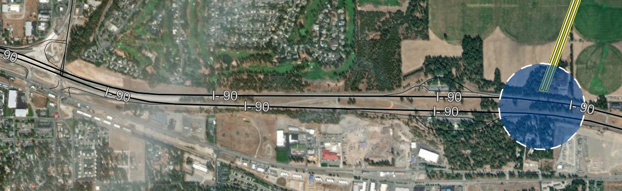
Figure 1. ITD Alternative H Ramps (not owned land)
The paragraph also addresses one location but not another. Spacing on Interstate 90 between existing interchanges is not the same as the spacing of proposed interchanges on a new Huetter-corridor facility. Community measurement of the Level 3 design using Kootenai County GeoViewer (KCEarth), recorded as a contested reading in the Group’s working review, places the relevant Huetter-to-SH-41 relationship nearer one mile (4,700 ft when using State-owned land) than two miles.
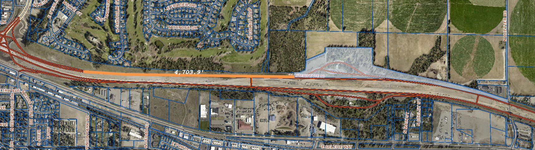
Figure 2. Distance from Owned Land
SH-41 Declared Outside Scope
Section 7 states that “historical decisions” on SH-41 “are outside the scope and authority of this study” (Hewitt, 2026). That limitation does not appear in the Group’s reading of the original PEL proposal as a public scoping bargain (No Huetter Bypass Group, 2026). A corridor PEL is required to evaluate existing conditions on the facilities that generate the congestion described in Purpose and Need. SH-41 is one of those facilities. The Findings Report documented the conversion of an intended higher-access-control corridor into a signalized arterial with closely spaced intersections (No Huetter Bypass Group, 2026a). That history is evidence about whether access control on a new 55–65 mph facility can be held for the life of the investment.
Refusing to examine that evidence is how the next SH-41 is designed. Section 7 adds that the PEL “considers how the facility can best function as part of the future transportation network” (Hewitt, 2026). Consideration without a documented access-management regime, enforceable spacing, and a joint-operations protocol with the highway districts is consideration in name only. Least private injury under Idaho Code should include not repeating a known access-control failure and fixing the ones that exist already.
Cost, Programming, and Technology
Independent Group estimates using adjusted state unit prices placed a Huetter-centered project far above earlier public figures near $300 million, with a working estimate nearer $800 million after post-2020 construction inflation and gaps in the presented Alternative H design (No Huetter Bypass Group, 2024, 2026). Those figures remain hypotheses. ITD’s Level 3 magazine publishes a conceptual cost of $564 million for Alternative H, against $252 million for Alternative D and roughly $1.05 billion for M and N, and prints the combined packages at $1.2 billion (N-D), $1.3 billion (N-D-B), $1.4 billion (N-H), and $1.5 billion (N-H-B) (Idaho Transportation Department, 2026b, pp. 16–17, 28–29). Section 10’s decision to leave costs “conceptual” until a preferred alternative advances runs counter to that disclosure (Hewitt, 2026). Qualitative “Medium Cost” labels from Level 2 cannot carry a necessity finding.
The adopted KMPO 2025–2031 Transportation Improvement Program, dated September 12, 2024, includes a line item titled “US 95, ALT ROUTE HUETTER BYPASS, NEPA STUDY, KOOTENAI CO” (Kootenai Metropolitan Planning Organization, 2024, p. 14). KMPO retitled that line item “Rathdrum Prairie PEL Study” by TIP Amendment 6, effective January 31, 2025, describing it as “a carry-over project funded in FY 2022” whose name and scope were “being revised to reflect conducting a Planning and Environmental Linkage (PEL) Study prior to entering into NEPA process” (Kootenai Metropolitan Planning Organization, 2025). That programming date is two years before the scheduled PEL completion. A corridor already listed for NEPA while screening is still open is not an open study. It is a preferred line already placed in the regional program. ITD has not responded to that point, and requests for details are now costing the public additional money.
Section 11 states that changes in vehicle technology, freight operations, transit, and travel behavior “are considered within the study’s future-year transportation analysis and do not, by themselves, dictate selection of a particular alternative” (Hewitt, 2026). Naming a variable and removing its weight is not analysis. Over a multi-decade horizon, operations tools can increase the effective capacity of existing lanes. Locking a fourth north-south general-purpose facility before those tools are tested is not required by 23 U.S.C. § 168 and is difficult to square with prudent use under 23 C.F.R. § 710.101 (Integration of Planning and Environmental Review, 2015/2022; Right-of-Way and Real Estate, 2016/2026).
Requested Actions
The Group therefore requests that District 1 suspend further development of any Alternatives, including D and H, as preferred PEL products until a bounded public re-screen is completed. The re-screen should score, as packages and with working files on the table, access management on U.S. 95, selected east-west connections including 16th Street-class links, targeted grade separations, Interstate 90 interchange operations, and the east-west function described in Alternative N. Alternative B and Element B should be brought to the same grain of travel-time, cost, displacement, and crossing detail used for D and H.
The Group further requests that ITD publish the “technical data,” including origin-destination matrices, model version and calibration year, unit prices, contingencies, and the numerical thresholds behind every screening face for Level 1 and Level 2 Alternatives, without routing that publication through a public-records request. Those files are planning products within the meaning of 23 U.S.C. § 168(a)(3) (Integration of Planning and Environmental Review, 2015/2022). ITD’s own Level 3 magazine states that the study’s planning products “may be adopted or incorporated into future National Environmental Policy Act (NEPA) studies, per 23 United States Code (USC) 168 or Federal Regulations (CFR) 450.212 and 450.318” (Idaho Transportation Department, 2026b, p. 1). That route is open only if the corridor study was conducted with a “reasonable opportunity to comment during the metropolitan transportation planning process and development of the corridor or subarea planning study” (23 C.F.R. § 450.318(b)(2)(iii)). They should be available for comment before any product of this PEL is adopted into NEPA.
Finally, the Group requests that condemnation remain the residual tool, not the foreseeable result of a screening path that never allowed least-injury packages to compete. Safety, legal crossings, and federal traffic-flow practice can be served on the existing primary highway and its east-west feeders. That work should be exhausted before a dual new roadway across private land is called necessary.
The Group is prepared to meet with District 1, Idaho Division, and the highway districts to re-screen the design.
Respectfully,
Brian Rogers
No Huetter Bypass Group
Post Falls, Idaho
References
American Association of State Highway and Transportation Officials. (2018). A policy on geometric design of highways and streets (7th ed.).
Federal Highway Administration. (2016, November 2). Planning and Environmental Linkages — questions and answers. U.S. Department of Transportation. https://www.fhwa.dot.gov/hep/guidance/pel/pelfaq16nov.cfm
HDR. (2024, May 6). Rathdrum Prairie PEL Study purpose and need memo [Memorandum to C. A. Hewitt and M. Hartz, Idaho Transportation Department, District 1]. https://itd.idaho.gov/wp-content/uploads/2025/05/23349-M-20240506-Purpose-and-Need-Memo.pdf
Hewitt, C. A. M. (2026, September 4). [Letter to Brian Rogers regarding Rathdrum Prairie PEL Level 3 response]. Idaho Transportation Department, District 1. ITD Response to the Rathdrum Prairie PEL Level 3 Response
Hewitt, C. A., Wilson, J., & Hartz, M. (2025, July 31). Rathdrum Prairie Area Transportation Study concepts and alternatives evaluation process methodology memo [Memorandum to S. Tipuric, FHWA Idaho Division]. Idaho Transportation Department, District 1. https://itd.idaho.gov/wp-content/uploads/2025/05/23349-M-20250731-Rathdrum-Prairie-Study-Alternatives-Evaluation-Process-Memo.pdf
Idaho Legislature. (n.d.-a). Idaho Code § 7-704: Facts prerequisite to taking. https://legislature.idaho.gov/statutesrules/idstat/Title7/T7CH7/SECT7-704/
Idaho Legislature. (n.d.-b). Idaho Code § 7-705: Survey and location of land. https://legislature.idaho.gov/statutesrules/idstat/Title7/T7CH7/SECT7-705/
Idaho Transportation Department. (2026a, September 15). Estimate summary: Invoice INV26-R002851-1, public records request R002851-090326 [Public Records Center record].
Idaho Transportation Department. (2026b, July). Level 3 alternatives screening results for public review and input [Rathdrum Prairie Area Transportation Study, Key Number 23349]. https://itd.idaho.gov/wp-content/uploads/2026/07/RathdrumPrairie-PIM5-Magazine-23349.pdf
Integration of planning and environmental review, 23 U.S.C. § 168 (2015 & Supp. 2022). https://www.law.cornell.edu/uscode/text/23/168
Kootenai Metropolitan Planning Organization. (2024, September 12). Transportation improvement program 2025–2031. https://www.kmpo.net/wp-content/uploads/2024/10/KMPO-2025-2031-TIP-V3.pdf
Kootenai Metropolitan Planning Organization. (2025, January 31). 2025–2031 KMPO TIP Amendment #6: Modification to KN 23349 Alt Route Huetter Bypass, NEPA Study, Kootenai Co. [Memorandum from G. F. Miles to N. Ipaye]. https://www.kmpo.net/wp-content/uploads/2025/01/2025-2031-KMPO-TIP-Amendment-6-Modify-KN-23349-Huetter-Corridor-to-Rathdrum-PEL-Study.pdf
No Huetter Bypass Group. (2024, December 8). Comments on Level 2 alternatives for the Rathdrum Prairie PEL study [Letter to CarrieAnnCarrie AnnCarrieAnn Hewitt]. Comments on Level 2 Alternatives for the Rathdrum Prairie PEL Study
No Huetter Bypass Group. (2026, July). Final report of findings. Rathdrum Prairie PEL Level 3 Response
Right-of-Way and Real Estate, 23 C.F.R. pt. 710 (2016 & amended 2026). https://www.ecfr.gov/current/title-23/chapter-I/subchapter-H/part-710
Rogers, B. (2026, July 19). Rathdrum Prairie Area Transportation Plan data [Email to C. A. Hewitt and others].
Statewide and nonmetropolitan and metropolitan transportation planning and programming, 23 C.F.R. § 450.316 (2017 & amended 2026). https://www.law.cornell.edu/cfr/text/23/450.316
Statewide and nonmetropolitan and metropolitan transportation planning and programming, 23 C.F.R. § 450.318 (2017 & amended 2026). https://www.law.cornell.edu/cfr/text/23/450.318
Statewide and nonmetropolitan and metropolitan transportation planning and programming, 23 C.F.R. § 450.324 (2017 & amended 2026). https://www.law.cornell.edu/cfr/text/23/450.324
Uniform Relocation Assistance and Real Property Acquisition for Federal and Federally-Assisted Programs, 49 C.F.R. § 24.102 (2024). https://www.ecfr.gov/current/title-49/subtitle-A/part-24/subpart-B/section-24.102
Uniform Relocation Assistance and Real Property Acquisition Policies for Federal and Federally Assisted Programs, 42 U.S.C. §§ 4651, 4655 (2018). https://www.law.cornell.edu/uscode/text/42/4651
Changes to this page
Showing the page as it reads today. Dotted underlines link to their entry below.
Revision 1 · · 1 change
Corrected the spelling of CarrieAnn Hewitt's first name.
- Change 1
Spelling
Carrie Ann→ CarrieAnn — Her first name is spelled CarrieAnn, as she signs her letters. Corrected everywhere it appears in this letter.