

No Huetter Bypass · Communications
Reply to ITD: Rathdrum Prairie Area and the Draft FY2027–FY2033 ITIP
by Brian Rogers 27 min read
On this page
This is the No Huetter Bypass Group’s reply to ITD’s response to the Draft ITIP comments, which answered the Group’s July 25, 2026 comment letter. The companion letter it refers to is the response to the ITD District 1 letter of September 4, 2026.
To: Robert Beachler, Planning and Scoping Program Manager, Idaho Transportation Department, District 1, 600 W. Prairie Ave., Coeur d’Alene, ID 83815
Copy to: ITIP Comments, itipcomments@itd.idaho.gov
From: Brian Rogers on behalf of the No Huetter Bypass Group
Date: October 6, 2026
Re: Reply to your email of September 4, 2026, “Rathdrum Prairie Area Transportation Study ITIP Comments” — Draft FY2027–FY2033 ITIP, Key Numbers 23349 and 24395
Companion filing: The Group’s October 2, 2026 letter to CarrieAnn M. Hewitt, P.E., replies to her September 4 District 1 letter and addresses the Level 3 screening record. It stands and is incorporated here.
Summary
Thank you for a specific, point-by-point reply. This letter makes one main point and a short list of supporting ones.
The main point. The Rathdrum Prairie is a road network managed by several agencies that plan together through KMPO but fund their programs separately. The idea that large programs can be built in a vacuum, or ahead of other work that affects traffic flow, does not align with the direction of the Federal Highway Administration’s guidance and other organizations that have matured their processes.
The Rathdrum Prairie study is only one part of the work affecting this network. The I-90 widening, the I-90/US-95 interchange and Appleway grade separation, the SH-41 and SH-53 projects, local arterial projects such as Prairie Avenue, and the timing of state and local signals are all changing traffic on the same network at the same time. Yet each is planned and funded on its own track.
Until all of that is shown as one system, with one cost table and a named sponsor for each piece, no single study can show that a new or wider corridor is the location of least private injury.
What I Ask
- Analyze the network as one system, every project and every signal, before any new alignment is advanced (this was the original intent of the Rathdrum Prairie study discussed years ago)
- Put the cost of the whole system on one short report through KMPO
- Reconcile the Key Number 24395 row and name the parcels
- Score the alternatives that stay inside existing corridors at the same level of detail as the ones that take land
- Publish the analysis the Department already has, without a fee
Where we agree, one correction, and a clarification
- Agreed: maintenance comes before expansion, and growth is real.
- Not contested: the completed US-95 work your reply lists (signals, spacing, medians, and fiber) and the I-90 widening contracts that have already been awarded. I take your description of that work as given. I have not seen the project records, and the SH-41 and US-95 section notes where the public record differs.
- Supported in principle: the Appleway grade separation and the pedestrian and ADA improvements, pending the project details requested in the section on Key Number 24395, the I-90/US-95 interchange.
- Agreed: ITD is not required to do the cities’, highway districts’, or county’s work. The community has never asked it to. What we have asked for is better, more cost-effective communication and coordination among the agencies, including how the money is programmed.
- Correction: I described Key Number 24395 as “Emma Avenue to Cherry Lane.” The Draft ITIP says Emma Avenue to Neider Avenue. KMPO’s draft TIP still says Cherry Lane (September 10, 2026 packet, PDF p. 63). Please confirm the limits.
- Clarification: my July comment set the order of work beside the revenue shortfall. The two do not have to be linked. Property should not be taken for a new corridor because the network has not been planned and funded as one system, and that would be true if the revenue had held. The cost picture is another reason to review the goals, not to protect anyone’s land.
One System. The Money is not Lined Up
The Department’s work on US-95 is real, and it is the Department’s own. Traffic leaving those signals enters arterials that belong to someone else. Whether those arterials are coordinated, widened, and access-managed informs any finding that the state needs more land.
The agencies do coordinate. ITD votes on the KMPO Board, KCATT meets at District 1, and the study runs on KMPO’s model. One gap is funding, and KMPO’s own documents say so.
| What the record says | Source |
|---|---|
| “Funding for transportation to support local arterial improvements continues to fall well behind in its ability to address capacity and rehabilitation needs. Discussions need to restart on local option funding sources and/or additional State sources …” | KMPO FY2027 work program (Sept 10, 2026 packet, PDF p. 22) |
| “It is, therefore, impractical to conduct a fiscal constraint analysis at the MPO level, as program funds and funding levels are managed and maintained by ITD.” | KMPO 2026–2032 TIP, p. 11 |
| The federal urban allocation KMPO directs is $2,170,651 a year. | Draft 2027–2033 TIP, Table 4.0 |
| In the 2024 call for projects, KCATT was told, “This year there will be about 1.6 million dollars available for local projects.” | KCATT, Sept 24, 2024, p. 5 |
| “… the project applications totaled nearly $42 million; there is only $5-7 million available.” | KCATT, Feb 25, 2020, p. 5 |
| The countywide registration fee and the one regional pooled fund failed. “With 33.6% of the votes, the measure fell short of the 50%-plus-one required to pass.” | KMPO Board, Nov 12, 2020, p. 4 |
| Local projects are funded through “State-wide competitive programs that are relegated to LHTAC for selection, programming and project management.” | KMPO FY2027 work program, same page |
| “A $900 million transportation need in Kootenai County over the next 20 years.” The budgets of local jurisdictions, “excluding ITD,” are “approximately $40 million a year.” | KMPO Board, Dec 12, 2019, p. 3 |
| Of Coeur d’Alene’s General Fund, which is not its street fund, “For FY 2027, the General Fund is projected to have a $1.9 million annual shortfall.” | City Council workshop, Apr 27, 2026, p. 2 |
| In the draft TIP, funding for FY2029–2033 is “less than $17 million, compared with the typical range of $20 million to $40 million per year.” Of $340 million, about $212 million is in preliminary development. | KCATT, July 28, 2026, p. 4 |
These figures show that state and local improvements are programmed separately even though they serve the same network. They support the request for a single system analysis and cost table; they are not offered as a separate reason to protect any particular property.
For fairness, the record also shows four things.
- A local option went unused: “Highway districts in Kootenai County have not exercised their local option vehicle registration fee” (KMPO 2020 Metropolitan Transportation Plan, p. 5-18).
- State law leaves few local options: KMPO’s director told KCATT the registration fee “was the only option in Idaho Code that was available for specifically addressing local transportation challenges” (KCATT, July 28, 2020, p. 5).
- Local agencies have done real work: Coeur d’Alene received a $1,235,158 grant for Ramsey Road signal upgrades that include “signal coordination to improve traffic flow” (City Council packet, Aug 18, 2026, p. 25), and “the city of Coeur d’Alene got their signal equipment upgrade approved for Government Way” (KMPO Board, Jan 2024, p. 4). On SH-41, “ITD funding for the project is $51.5 million, with another $5.7 million contributed by the cities of Post Falls and Rathdrum” (ITD news release, May 12, 2021). On the US-95 FASTLANE project, “ITD will contribute $865,000 in gas tax dollars and local jurisdictions 10%” (KMPO Board, Aug 11, 2016, p. 5).
- The one regional signal investment did not hold: In 2009 KMPO put $500,000 of ITS funds into ITD’s US-95 controller upgrade “so that adaptive signal technology can and will be used,” a recommendation of KMPO’s own US-95 Access Study (KMPO Board, May 7, 2009, p. 4; KCATT, Apr 28, 2009, p. 7). By 2016, “the adaptive system for the signals through the Highway 95 corridor had shut down” (KCATT, Mar 22, 2016, p. 8), and in late 2017 the corridor was “time-based - not adaptive” (KCATT, Nov 28, 2017, p. 5). KMPO’s 2026 plan text still lists “Traffic Signal timing plan failures as traffic on competing legs of intersections place demands for green time” as a current effect (KCATT packet, Jan 2026, PDF p. 49). I have found no regional plan adopted since then for running state and local signals as one network.
How this becomes a self-fulfilling need for land
This section is based on the reasoning from the record above.
- State and local money are programmed through separate channels.
- The local arterials fall behind on capacity and operations.
- The regional forecast carries that unimproved local network forward.
- The state highway shows as over capacity.
- The state study calls for a new or wider corridor, and land is taken.
- The take does not change how the money is programmed, so the next study starts from the same place.
The same steps as a decision diagram. The left path is the loop. The right path on Step 3 is what this letter asks for.
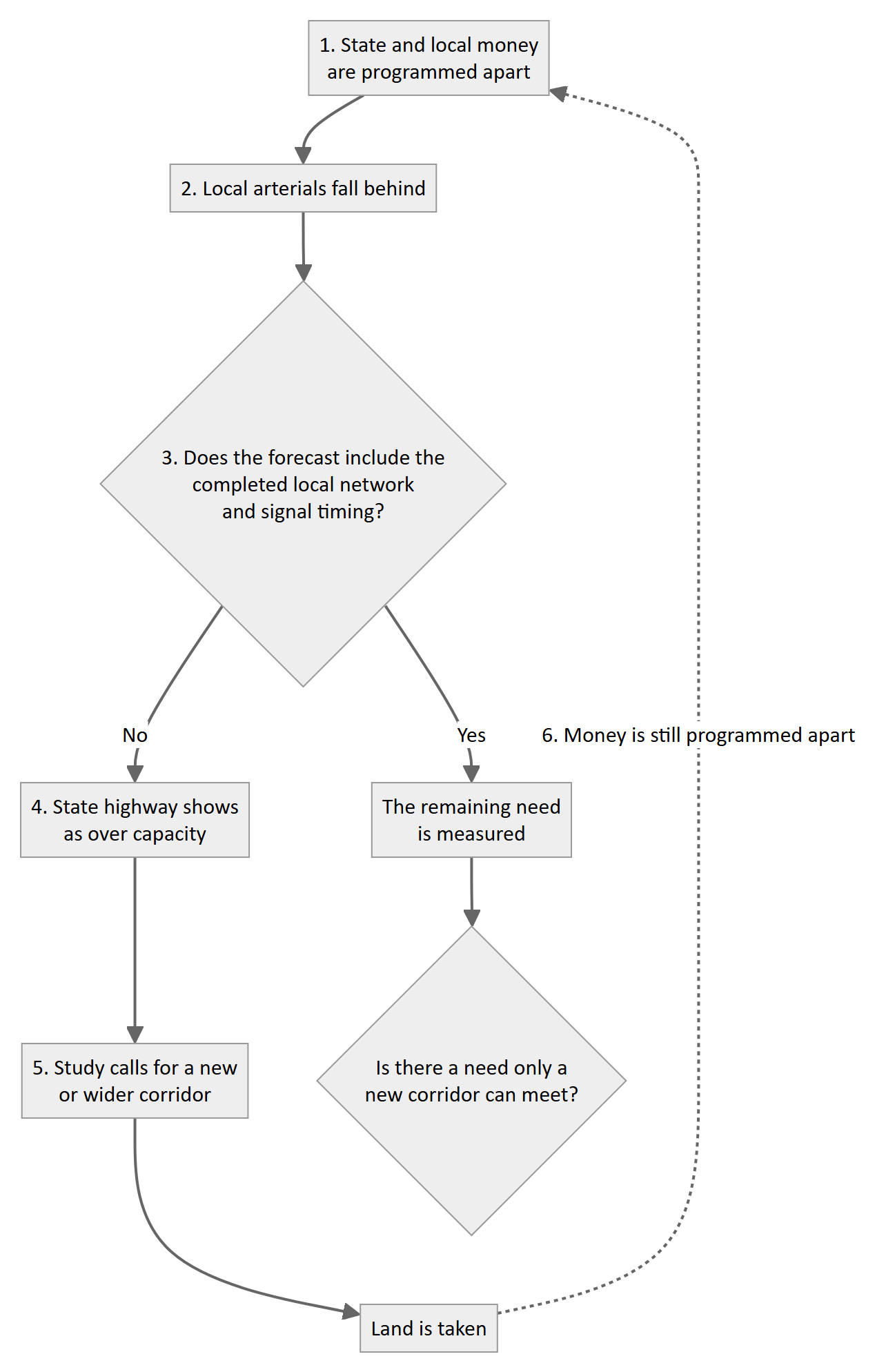
The loop as a decision diagram.
As logic. The loop is a chain of “if this, then that.” If the money is programmed apart, the arterials fall behind. If the arterials fall behind, the forecast shows the highway over capacity. If the highway is over capacity, a new corridor is needed. The chain holds together, but its conclusion is only as true as its first step. That first step is a choice the agencies can change, so the conclusion has not yet been shown to be necessary.
As arithmetic.
| Quantity | How it is worked out |
|---|---|
| Need shown by the study | forecast demand − capacity of the network as modeled |
| Need that actually remains | forecast demand − (capacity as modeled + local improvements + coordinated signals) |
| Amount by which the need is overstated | local improvements + coordinated signals left out of the model |
I put no numbers on these because the record does not supply them. Request 15 asks the Department for them.
Each step may be reasonable on its own. Together, however, the steps may make a new corridor appear necessary partly because state and local improvements are funded and modeled separately. Businesses encounter a similar problem when divisions share a roadmap but maintain separate budgets: each division can meet its own targets while the product still shows the seams. Here, the product is the road network, and the consequences include impacts to homes and farms. Engineers know this organizational pattern as Conway’s Law, which says that “organizations which design systems … are constrained to produce designs which are copies of the communication structures of these organizations” (M. Conway, “How Do Committees Invent?”, Datamation, April 1968).
A federal model offers an alternative. FHWA’s Integrated Corridor Management program describes agencies that “manage the corridor as a multimodal system and make operational decisions for the benefit of the corridor as a whole, and not just for the singular facility” (FHWA-HOP-19-039, ch. 1).
The Department knows this model. Its own statewide operations program says, “By integrating operations into planning and coordinating across agencies, ITD is saving lives, saving time, and ensuring smarter use of transportation dollars” (National Operations Center of Excellence case study, 2025). I ask that we apply the same approach here.
Two facts show how close this is. In March 2026, KMPO’s modeler reported that the regional model update “will be to add signal timing” because “some locations are not flowing correctly” (KCATT, March 24, 2026, p. 4). Whether the study’s screening runs had signal timing is a question I ask in the forecast section. And asked for the easiest and most affordable way to relieve US-95, ITD’s engineering manager told the Transportation Board that “putting a third lane would be the most efficient because ITD owns the right-of-way” (ITB minutes, July 15–16, 2026, p. 7).
What a system analysis must show before a new alignment advances:
- (a) a base case with only funded improvements, including the I-90 widening, the interchange and grade-separation projects, and the SH-41 and SH-53 work as actually programmed
- (b) a completed-system case with the local Elements, access conformance, and coordinated timing of every signal on the Prairie, state, and local, costed and assigned
- (c) that signal timing represented in the model
- (d) the need that remains
- (e) parcels, acres, and displacements for each case
- (f) the crash expectation for each case
- (g) who does what, and what happens if a piece is not built
Your reply says many public ideas became Elements “that can be made by the respective city, highway districts, or ITD.” That says who could do the work. It does not say who will do it, when, or with what money. Even if KMPO’s regional plan is not adequate to carry this out, residents need to be told so plainly, with a clear statement of what has to happen and who has to do it. The study’s implementation plan is the place.
SH-41 and US-95: what the Department’s own corridors show
I raise these as evidence of what happens when state and local decisions are not made together.
SH-41
- The 2002 corridor plan was “accepted by local jurisdictions, but not adopted by ITD” (KCATT, Mar 25, 2014, p. 5).
- In 2015 ITD moved to designate it an expressway, then “decided to leave the designation of Highway 41 as principle arterial,” with added access “handled on a case-by-case basis” (KMPO Board, Aug 13, 2015, p. 5; KCATT, Aug 25, 2015, p. 4).
- The 2016 plan said, “No development of private property driveways will be allowed on Highway 41.” By 2020, ITD staff said, “the 20-acre splits can be done without any comment from the state” (KCATT, Sept 22, 2020) and “IDAPA was trumping the local ordinance, and ITD is losing the battles” (KCATT, Nov 24, 2020).
- Signal coordination called for in 2016 was still being added in 2024, after the widening opened.
- The District Engineer said locals “have been stronger on access than ITD has been able to be” (KMPO Board, Jan 14, 2021, p. 4).
US-95
- “ITD had just spent $11 million correcting the access spacing along US-95 and said they do not want to create the same issue along SH-41” (KCATT, Sept 22, 2020, p. 7).
- By ITD’s account, the correction worked. Crashes at Canfield fell from about 18 a year to 1, and the project won an award. It was also announced for completion by the summer of 2019 and was reported substantially complete in October 2020, and the new turn lanes at Wilbur and Miles “were not long enough” and had to be extended.
- Signal technology that District 1 described in 2017, as quoted in the Coeur d’Alene Press, as adaptive “unlike any other in the state” had, by ITD’s 2023 account, “largely not been updated since before 2010.”
The lesson. Access on a state highway depends on county land division, city zoning, district permits, and a state rule, IDAPA 39.03.42, that ITD’s own engineers say limits them. Fixing it afterward cost more than $10 million on US-95. A new Prairie corridor would face all of that. The rule is the Department’s to administer and to propose changes to. Holding the land-use side is the local agencies’. Both belong in the study.
The forecast
The statewide population figures in your email check out. Two county figures do not.
| Item | Your email | Published | Gap |
|---|---|---|---|
| 2025 county population | 194,941 | 191,864 (Census, July 1, 2025) | 3,077 high |
| Horizon forecast | 339,542 by 2050 | 319,404 by 2045 (adopted by KMPO) | Different series |
| County growth implied by your figures | 2.24% a year | ||
| I-90 traffic “doubling by 2045” | 3.53% a year | 1.57 times the population rate |
At the 2.24 percent a year implied by your own 2025 and 2050 county figures, 61,000 vehicles a day becomes about 95,100 in 2045, against 122,000 if the volume doubles. Through-trips and freight may explain the rest, but it has not been shown. Please publish the model version, inputs, and assumptions; state whether the model includes induced travel; and state whether the runs behind the screen represented signal timing.
I-90 and weaving
I heard your statements about the contracts, the incident-clearance reason, and the bridge reason. Two things are unanswered.
- Asked about the widening, your reply pointed to the interchange (Key Number 24395) being unfunded. That is a different project.
- The reply gives no weaving analysis. Adding lanes between SH-41 and US-95 while Exit 12 stays as built changes the lane-change task on a four-mile segment with trucks and winter weather. Your reply says the widening will deliver relief, that the interchange cannot meet demand, and that the interchange is unfunded. Please show the 2029 operations with all three true.
The Draft ITIP also reports interstate person-miles traveled that are reliable at 98.8 percent statewide, against a 90 percent target. A statewide number can hide four bad miles, so the case has to be made at the corridor level. The safety and TREDIS benefit-cost analyses the ITIP describes are that evidence. Please publish them.
Key Number 23349: Rathdrum Prairie Area Transportation Study
A study you say finishes in 2026 carries $2.0 million of preliminary engineering in FY2027. Please say whether it funds closeout of the planning document or the start of NEPA on a preferred alignment.
Finishing the study does not adopt it into NEPA (23 U.S.C. § 168(f)(1)). Section 168(d) sets conditions for adoption, including reliable, current data; no significant new information; and approval within five years. Please state the approval date.
I continue to ask that the study be terminated because, as set out in the Group’s October 2, 2026 letter to CarrieAnn M. Hewitt, P.E., the process contained unresolved accuracy problems and did not address issues raised during the study.
If the Department declines, I ask that the study’s content not be carried into NEPA. Section 168(d) allows a planning product to be adopted only if it rests on reliable and current data and no significant new information undermines it. A study with those unresolved problems does not yet meet that test. At a minimum, NEPA should not begin on any new alignment until the existing-corridor options are scored as packages at the same level of detail, and the system analysis in the section on the loop is published. Please state what remains of the study’s $5.15 million lifetime amount, and whether this work fits inside it.
Key Number 24395: I-90/US-95 interchange, Emma Avenue to Neider Avenue
The row shows construction of $128.36 million as Unfunded, with $10.0 million of right-of-way and $6.0 million of preliminary engineering in FY2027 (Draft FY2027–FY2033 ITIP, District 1 Highways Project List, PDF p. 29; the same row is in KMPO’s draft TIP, Sept 10, 2026 packet, PDF p. 53). District 1’s May 5, 2026 letter to KMPO says “the NEPA documentation for the I-90 corridor from SH-41 to 15th Street was approved by FHWA on April 14, 2025,” and that “some of the right-of-way can be purchased without any re-evaluation” (KMPO Board packet, June 2026, PDF pp. 9–10). KCATT was told the plan was to “start final design and right-of-way acquisitions in the winter 2026, funding dependent” (KCATT minutes, Dec 16, 2025, p. 5).
So acquisition is planned before construction is funded. In KMPO’s draft program, the $11.5 million of FY2027 right-of-way is on two state projects whose construction is unfunded. My concern is the system first, with the budget as a further reason to look again. The revised design relies on new connections that “will ultimately become City-owned streets,” and on a US-95 you describe as at capacity. 23 C.F.R. § 771.111(f) asks that an action have independent utility, meaning it is usable and a reasonable expenditure even if no other improvement in the area is made. I ask that this be shown for each phase before parcels are bought for it. The Appleway grade separation itself is not the objection.
Please state:
- which parcels will be appraised or acquired in FY2027, by phase, and which lie inside the 2025 footprint;
- the status of the re-evaluations, and the authority for any acquisition outside that footprint;
- how independent utility is shown for each phase, and whether the City has agreed to accept the new streets;
- whether the Exit 12 replacement is a change in Interstate access under 23 C.F.R. Part 624; and
- whether the project is illustrative under 23 C.F.R. § 450.218(l), and how full funding is reasonably anticipated under § 450.218(o).
A listing is not a taking, and I do not claim otherwise. Owners still cannot plan while a line sits on an official program, so the label should be accurate.
The alternatives that were not scored
- Alternative B. Your reply says ITD “has maximized the capacity of the existing US-95 corridor,” and also that six lanes on US-95 “would address congestion on US-95.” These two statements need reconciling. If six lanes would address the congestion, the corridor’s options would not have been exhausted. Also, there are additional ways to improve traffic besides more lanes; these need to be reviewed and presented. B was set aside because it “didn’t perform well for the whole study area on its own.” The congestion you describe is on US-95. Please score B as its own alternative.
- The rejected options are not public. Without those documents, no one outside the Department can determine whether the existing-corridor options were screened to the same standard as the new-alignment packages or whether a less costly redesign was passed over. Until the underlying analysis is available for review, we cannot independently evaluate the conclusion. Requests 8 and 13 ask for that material.
- Road diets and lane counts. Your reply states there are “no three or four lane arterials within the study area.” Prairie Avenue is four lanes with a center turn lane, which is the cross-section FHWA’s road-diet guide addresses, so the statement does not hold as written. Please reconcile it with Prairie Avenue and publish the arterial inventory the answer rests on. The added statement that road diets apply to “heavily developed metropolitan areas” also does not reflect what the guide shows. Its largest crash reduction, 47 percent, came from an Iowa sample of state routes through small towns. I do not apply that figure to any Prairie road. The same question runs the other way on Atlas Road, which the draft TIP would “reconstruct … and widen to three lanes” (Key Number 24647). Before widening any arterial on the Prairie, the record should show whether signal timing, approach consolidation, and properly sized turn lanes meet the needs of the existing section. Lanes added on local arterials feed the same forecast used to justify a new state corridor.
- Access management. IDAPA 39.03.42 Table 1 sets five distances by highway type and area type. “One-half mile” matches two different cells. If US-95 is classed as Urban, one-half mile is the signal spacing, and the public-road spacing is 1,320 feet. Please state the classification of each US-95 segment, the distances that follow, and the variances granted since FASTLANE.
- Grade separations. These were dropped on US-95 for cost, right-of-way, and business impact. The same program carries a $128 million interchange with a grade separation at Appleway, and no cost or right-of-way has been published for a new alignment. Please put both in one table showing parcels, acres, displacements, and cost.
- Frontage roads. A controlled highway plus a parallel local road is two facilities and a wider taking. Who builds and maintains the second one is a state-and-local question.
- The nineteen Elements. For each, give the description, sponsor, cost, and key number. An Element with none of these is not yet a program.
KMPO
My July comment asked that KMPO funding be removed “until the organization approaches the residents with plans that align to the needs of the community.” That was conditional, and the plan it describes is the one in the funding section: state and local work, costed, on one page.
Two ordinary provisions apply. The first is the self-certification under 23 C.F.R. § 450.336(a) that accompanies this STIP. The second is “status of planning” as a factor in the state’s distribution formula under 23 U.S.C. § 104(d)(2). I ask that the certification document how the Rathdrum Prairie study met §§ 450.316 and 450.318.
Public access to the record
In August 2025, District 1 wrote that a full version of the Level 2 data “will address the questions that you had.” In November 2025, it wrote that such data requires a public records request, and called KMPO’s data “proprietary.”
On September 3, 2026, the Group requested meeting records between ITD, KMPO, and the consultant. The estimate was $123.74, including $104.33 for format conversion. ITD waived the first two hours, as the statute provides. The September 21 notice gave 60 days to respond, and the invoice gave an October 15 due date. The request was closed on September 25, four business days after that notice. This behavior makes it impossible to acquire public information.
I do not agree that this material should carry a fee. As the Group’s October 2, 2026 letter to CarrieAnn M. Hewitt, P.E., sets out, a list of meetings, agendas, and minutes for a public planning study should be available to the public. I ask that it be released without charge as part of the study record, and that the Department state which deadline governed the closure and under what authority.
The practical effect matters more than the amount. If a simple list of meetings and agendas costs $123.74, including a charge for attorney review, the community cannot see what work has been done and therefore cannot know what to ask for. If state and local work are to be planned as one system, the data both rely on should be public in one place.
Requests
Numbers 1–14 match my July 25 comment. Numbers 15–19 are new.
One system
- 12. One cost table, through KMPO. KMPO says it cannot test the program at the regional level because ITD manages the funds, so I ask ITD to supply the figures and KMPO to publish the page. For each package still carried and for the existing-corridor package, list every state and local improvement with sponsor, cost, year, and funding status. One total per package.
- 15. System analysis first. Publish items (a) to (g) in the section on the loop before any new alignment goes to NEPA, right-of-way mapping, or the Board.
- 16. Access protocol. One for US-95 and SH-41 with the county, cities, and districts, with the cost and parcel count to finish access conformance.
- 17. The access rule. State the outcome of the 2021 request for an Attorney General opinion, whether the Board adopted the 2016 SH-41 plan, and whether ITD will propose changes to IDAPA 39.03.42.
- 18. Implementation plan. Publish it, and for each state and local piece, state who is responsible, the cost, whether it is funded, and what changes if it is not built.
- 19. Signals as one network. Identify any regional plan adopted since August 2023 for timing all signals on the Prairie together, and who owns them. If there is none, say what ITD will offer the local agencies, and whether it will use FHWA’s Integrated Corridor Management approach as the model.
Program Accounting
- 1. I-90 widening. Awarded, obligated, expended, remaining, change orders, and any scope not under contract.
- 6. Key Number 24395. Reconcile the row, answer the five questions in the section on Key Number 24395, the I-90/US-95 interchange, and confirm the limits.
Analysis the Department already has
- 2. 2029 operations, including weaving, for I-90 with Exit 12 as built.
- 3. Forecast files, as described in the forecast section.
- 10. Benefit-cost analyses for Key Number 24395 and for the existing-corridor package.
Alternatives
- 4. Key Number 23349. Terminate the study. If the Department declines, do not carry its content into NEPA while the problems in the October 2, 2026 letter remain unresolved; re-screen first. State what the $2.0 million funds and the § 168(d) approval date.
- 5. Alternative B scored alone, and within an operations and access package, including the third lane inside the right-of-way ITD already owns.
- 7. Arterial inventory behind the road-diet answer, reconciled with Prairie Avenue, and for Atlas Road and any other arterial proposed for widening, an analysis of whether signal timing, approach consolidation, and turn lanes meet the need on the existing section.
- 8. Grade-separation and access comparison, including segment classifications and variances, and the concepts, cost estimates, and footprints for every US-95 grade separation and redesign evaluated and set aside.
- 9. Elements list with sponsor, cost, and key number.
Process
- 11. KMPO. The self-certification record described in the KMPO section.
- 13. Release the technical material as a planning product, and release the meeting list, agendas, and minutes sought in request R002851-090326 without charge.
- 14. Meet with District 1, FHWA, KMPO, the cities, the county, and the districts to design the re-screen and the system analysis.
Closing
Your reply shows the Department knows how to do its half at times. It grade-separated the plan at Appleway, removed the signal at Canfield, and rebuilt the US-95 signals. The local agencies have done some of their part. What is missing is the plan that connects the two halves, says what each costs and who pays, and only then asks how much land is left to take.
The Department is not responsible for the local agencies’ work. It is the one agency that sees the whole network. The sequence that takes the fewest homes is the one that finishes the system people already drive, state and local together, before a new line is drawn.
Thank you for a serious response. I look forward to your reply.
Respectfully,
Brian Rogers
References
Each citation in the text is linked to the source below. Page numbers in the text are PDF page numbers unless stated. KMPO and KCATT records are from kmpo.net; the City of Coeur d’Alene records are from cdaid.org.
- KMPO, FY2027 Unified Planning Work Program, in the KMPO Board packet of September 10, 2026. https://www.kmpo.net/wp-content/uploads/2026/09/091026-Packet-rs.pdf
- KMPO, Draft 2027–2033 Transportation Improvement Program, in the KMPO Board packet of September 10, 2026 (Tables 1.0, 3.0 and 4.0; Key Numbers 24395 and 24647). https://www.kmpo.net/wp-content/uploads/2026/09/091026-Packet-rs-1.pdf
- KMPO, 2026–2032 Transportation Improvement Program, adopted October 9, 2025. https://www.kmpo.net/wp-content/uploads/2025/11/KMPO-2026-2032-TIP-Final-Adopted.pdf
- KMPO, 2020 Metropolitan Transportation Plan, Section 5. https://www.kmpo.net/wp-content/uploads/2020/04/KMPO-Section-5-2020-MTP-FINAL-3-19-20.pdf
- KCATT meeting minutes, September 24, 2024. https://www.kmpo.net/wp-content/uploads/2024/10/KCATT_September-2024_Agenda-Minutes-Approved.pdf
- KCATT meeting minutes, February 25, 2020. https://www.kmpo.net/wp-content/uploads/2020/04/2020-02-25_kcatt_agenda_minutes.pdf
- KMPO Board meeting minutes, November 12, 2020. https://www.kmpo.net/wp-content/uploads/2021/01/2020-11-12_kmpo_agenda_minutes.pdf
- KMPO Board meeting minutes, December 12, 2019. https://www.kmpo.net/wp-content/uploads/2020/01/2019-12-12_kmpo_agenda_minutes.pdf
- City of Coeur d’Alene, City Council budget workshop minutes, April 27, 2026. https://www.cdaid.org/media/zoelrlko/042726-cc-budget-workshop-ada.pdf
- KCATT meeting minutes, July 28, 2026. https://www.kmpo.net/wp-content/uploads/2026/08/July-28.pdf
- KCATT meeting minutes, July 28, 2020. https://www.kmpo.net/wp-content/uploads/2020/08/2020-07-28_kcatt_agenda_minutes.pdf
- City of Coeur d’Alene, City Council packet, August 18, 2026. https://www.cdaid.org/media/c2kh0ian/packet-081826-web-rev-081426.pdf
- KMPO Board meeting minutes, January 11, 2024. https://www.kmpo.net/wp-content/uploads/2024/08/KMPO-Board_January-2024_Agenda-Minutes-Approved.pdf
- Idaho Transportation Department, news release, “New railroad overpass on ID-41 opens tomorrow,” May 12, 2021. https://apps.itd.idaho.gov/Apps/MediaManagerMVC/PressRelease/Preview/9598
- KMPO Board meeting minutes, August 11, 2016. http://www.kmpo.net/wp-content/uploads/2018/09/2016-08-11_kmpo_revisedagenda_minutes.pdf
- M. E. Conway, “How Do Committees Invent?”, Datamation, April 1968. https://www.melconway.com/Home/Committees_Paper.html
- Federal Highway Administration, Integrated Corridor Management, FHWA-HOP-19-039, Chapter 1. https://ops.fhwa.dot.gov/publications/fhwahop19039/ch1.htm
- KMPO Board meeting minutes, December 14, 2017. http://www.kmpo.net/wp-content/uploads/2018/09/2017-12-14_kmpo_agenda_minutes.pdf
- National Operations Center of Excellence, “A TSMO Transformation at the Idaho Transportation Department,” case study, 2025. https://transportationops.org/case-studies/tsmo-transformation-idaho-transportation-department-itd
- KCATT meeting minutes, March 24, 2026. https://www.kmpo.net/wp-content/uploads/2026/04/KCATT-March-2026_Agenda-Minutes-Approved.pdf
- Idaho Transportation Board, meeting minutes, July 15–16, 2026. https://itd.idaho.gov/wp-content/uploads/2026/01/BoardminJuly2026.pdf
- KCATT meeting minutes, March 25, 2014. http://www.kmpo.net/wp-content/uploads/2018/09/2014-03-25_kcatt_agenda_minutes.pdf
- KMPO Board meeting minutes, August 13, 2015. http://www.kmpo.net/wp-content/uploads/2018/09/2015-08-13_kmpo_agenda_minutes.pdf
- KCATT meeting minutes, August 25, 2015. http://www.kmpo.net/wp-content/uploads/2018/09/2015-08-25_kcatt_agenda_minutes.pdf
- KCATT meeting minutes, September 22, 2020. https://www.kmpo.net/wp-content/uploads/2020/10/2020-09-22_kcatt_agenda_minutes.pdf
- KCATT meeting minutes, November 24, 2020. https://www.kmpo.net/wp-content/uploads/2020/12/2020-11-24_kcatt_agenda_minutes.pdf
- KMPO Board meeting minutes, January 14, 2021. https://www.kmpo.net/wp-content/uploads/2021/02/2021-01-14_kmpo_agenda_minutes.pdf
- Idaho Transportation Department, Draft FY2027–FY2033 Idaho Transportation Investment Program, July 2026. https://apps.itd.idaho.gov/Apps/Fund/itip2027/draft/FY27_Draft-ITIP.pdf
- Idaho Transportation Department, District 1, letter to KMPO on Key Number 24395, May 5, 2026, in the KMPO Board packet of June 2026. https://www.kmpo.net/wp-content/uploads/2026/06/KMPO-Board-Meeting_June-2026_Packet.pdf
- KCATT packet, January 27, 2026, including the December 16, 2025 meeting minutes and the draft 2026 plan text (PDF p. 49). https://www.kmpo.net/wp-content/uploads/2026/01/KCATT_January_2026-Packet-Final.pdf
- U.S. Census Bureau, QuickFacts, Kootenai County, Idaho. https://www.census.gov/quickfacts/kootenaicountyidaho
- KMPO Board meeting minutes, June 9, 2022 (2020–2045 population projections). https://www.kmpo.net/wp-content/uploads/2022/07/2022-06-09_kmpo_agenda_minutes_.pdf
- 23 U.S.C. § 168, Integration of planning and environmental review. https://www.law.cornell.edu/uscode/text/23/168
- 23 C.F.R. § 771.111, Early coordination, public involvement, and project development. https://www.ecfr.gov/current/title-23/section-771.111
- 23 C.F.R. Part 624, Access to the Interstate System. https://www.ecfr.gov/current/title-23/part-624
- 23 C.F.R. § 450.218, Development and content of the statewide transportation improvement program. https://www.ecfr.gov/current/title-23/section-450.218
- 23 C.F.R. §§ 450.316, 450.318 and 450.336, Metropolitan transportation planning. https://www.ecfr.gov/current/title-23/part-450/subpart-C
- 23 U.S.C. § 104, Apportionment. https://www.law.cornell.edu/uscode/text/23/104
- IDAPA 39.03.42, Rules Governing Highway Right-of-Way Encroachments on State Rights-of-Way. https://adminrules.idaho.gov/rules/current/39/390342.pdf
- Federal Highway Administration, Road Diet Informational Guide, FHWA-SA-14-028. https://highways.dot.gov/sites/fhwa.dot.gov/files/2022-06/rdig.pdf
- KMPO Board meeting minutes, May 7, 2009. https://www.kmpo.net/wp-content/uploads/2018/09/2009-05-07_kmpoboard_minutes.pdf
- KCATT meeting minutes, April 28, 2009. https://www.kmpo.net/wp-content/uploads/2018/09/2009-04-28_kcatt_minutes.pdf
- KCATT meeting minutes, March 22, 2016. https://www.kmpo.net/wp-content/uploads/2018/09/2016-03-22_kcatt_agenda_minutes.pdf
- KCATT meeting minutes, November 28, 2017. https://www.kmpo.net/wp-content/uploads/2018/09/2017-11-28_kcatt_agenda_minutes.pdf